Monday, February 27, 2012

One Trail Twelve Times - February

An American beech (Fagus grandifolia) that looks like it's bearing the weight of the world.
I wonder why those bulges develop?
I led the the second installment of my "one trail walked 12 times " over the course of a year program a week ago on Sunday afternoon, February 19.  The day was cold (like it was during the January jaunt), but unlike January it was sunny and snowless.
A pine sapling barked by a buck rubbing its antlers
 Emerging from the woods into the meadows (which are bisected by a church's driveway)
Praying mantis (Mantis spp.) egg case on a blackberry cane (Rubus spp.)In looking up the scientific binomial of the the mantis, I learned that there are two mantid species living in the northern and eastern United States, both of which were introduced, one from Europe and one from China (the Chinese mantid is in a different genus!  Native mantids are only found in the southern states.
Shriveled fruit of horse nettle or ground cherry (Solanum carolinense).  When they're ripe, you can make a jelly from the fruits of this native weed in the tomato family (Solanaceae).
You can tell it's been a mild winter: multiflora rose (Rosa multiflora) hips are still to be found in February
 Persistent seed heads of a pioneer tuliptree (Liriodendron tulipifera)
 Navigating the damp lower end of the meadows before entering the woods
 Hikers on the footbridge spanning the ravine
 Pointing out skunkcabbage emerging from the winter's duff in the spring run
Skunkcabbage (Symplocarpus foetidus)
Mossy rocks in the spring run
One of the trail's eponymous springs
Rent asunder by lightning
Assorted vertebrae from a hapless white-tailed deer (Odocoileus virginiana)
The final leg of the trail leads through an allee of white pines planted in the 1920s 
I wish that I could devote a bit more time to composing my images, but leading the walk, trying to find and point out interesting natural history features, and taking pictures make photography challenging.

Saturday, February 25, 2012

The Mysterious Island

A view upstream along my creek.  The "mysterious" island is on the right bank

Picking up on a theme of a current family adventure film, but without bees the size of rhinoceroses...

Ever since I came to my preserve, I've been fascinated by a fairly sizable island (2-3 acres) in my creek.  The smaller streams in the Mid-Atlantic don't have islands; the valleys are too deeply incised into our metamorphic and sedimentary bedrock to form islands.  These streams are straightforward down cutters.  So, how to explain this rocky, wooded island? 

I've also been concerned that I am "losing" the forest on the island.  The trees at the edge are being undercut by the current...
...and flooding from severe storms washes over the center of the island and topples trees and removes topsoil.  Surely, this landscape isn't long for this world.

I've worried and puzzled over this situation for years.  I had some suspicion that it was related to the long-breached colonial mill dam located just downstream from the lower tip of the island but couldn't put the puzzle together fully.

Then, in 2008, a seminal paper appeared in the journal Science.  The two authors posited that all of the streambeds in the Mid-Atlantic had been significantly modified through the construction of colonial water powered mill dams.  Now that the dams had either breached naturally or had been removed purposefully, the streams were regaining their natural channels and were quickly washing away the "legacy sediments" that had accumulated behind the mill dams.  Furthermore, the urbanization of these same watersheds generates rapid and excessive runoff, so legacy sediment removal was progressing even faster than it would if the watersheds had returned to more natural conditions after the milling operations ceased.  Exactly the explanation I had sought for the disappearance of my island.

I'm still distressed that the forest, with some remarkably large American beech, oaks, and tuliptrees is washing away, but this really only represents a return to more natural conditions in the streambed.  Of course, try to tell that to the aquatic invertebrates that are smothered by the eroding sediments after each storm.
A view downstream at the head of the island where the creek divides

Ruins of the stone foundation of a water powered mill located just upstream of the island

Friday, February 24, 2012

They're baaaack...!

I've been really busy during the last week, so I haven't had much time to prepare posts, though I have a few in the works.

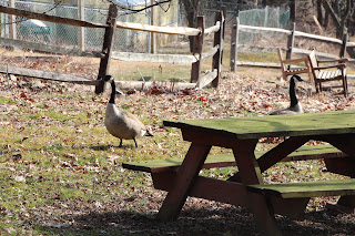
Last Thursday (February 16), "my" pair of Canada geese showed up again, begging for birdseed.
 In the spring of 2010, a pair of Canada geese took up residence in the 0.1-acre pond a few hundred feet behind and downhill from my house.  There's a tiny island in the pond, just big enough for a goose nest, and the geese defended their territory against all comers.  Watching me feed the flock of turkeys that hung around begging for handouts, the geese eventually waddled up the hill--across a field of recently cut multiflora roses (ouch!)--and stared at me plaintively until I brought them some seed, too.  Even though I was feeding them, they hissed at me if I got too close.  And, so it went on a daily basis during most of the spring.
Then we had a long rainy period.  The water level in the pond rose so high one night that it inundated the island, drowning the nest and the eggs.  The geese hung around in the pond, disconsolate, for a few days, then disappeared.

Last spring, the geese reappeared.  It took less than a day for them to make their way up the slope for a handout, so I was pretty sure it was the same pair as the year before.  Despite daily--and sometimes multiple daily--feedings, I still got the royal hiss if I dared to approach too closely.  Unfortunately, their nest was inundated by spring rains once again last year.

Now the geese are back for another try.  Perhaps the third time's a charm.

A pair of geese always claims the island each spring; I don't know if it's the current pair.  When the nest doesn't drown, the geese usually produce a fairly sizable brood of goslings.  Maybe it's better that the nest drowns, though, because during the years in which the geese successfully hatch a brood, most--if not all--of the goslings are lost to the big snapping turtles that cruise just below the surface of the pond.
 Certainly, we don't need any more Canada geese, but I feel sorry for "my" pair that invest so much time and energy into tending their nest, only to have it lost to meteorological vagaries. So, I'll keep feeding them and tolerating their insolent hissing.

Wednesday, February 8, 2012

Sunny Sunday Afternoon

 
Sunny meadow last Sunday afternoon.  Alas, the field was mowed on 
Monday morning as part of our meadow management regime.

The preserve over which I am steward contains the second (1817) and third (1840) oldest extant bridges in our county.  They no longer bear traffic and have been incorporated into our trail system.  This is a view of the second-oldest bridge, viewed upstream.
Unfortunately, age and torrential flooding have taken their toll over the years.  In the early '90s, we invested over $60,000 in this bridge.  Lately, we discovered that the footer for the pier standing in the creek is deteriorating and will have to be repaired.
In addition, graffiti vandals have "discovered" the bridge.  For years, we had few problems with graffiti, but it's becoming more and more pervasive.
On the other hand, if you ignore the spray paint and the failing  masonry, the view is still nice!

Monday, February 6, 2012

Cynwyd Trail


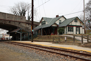
The Cynwyd station--end of the line for active rail service

Kali and I explored a new urban trail on a cool, damp and cloudy Saturday afternoon this weekend--the Cynwyd Heritage Trail.  This trail was created when one of the regional rail lines serving Philadelphia was discontinued.  The rails were removed and the trail was created in their place.

The trail, completed in May 2011, consists of two parallel paths, one paved for bicyclists and in-line skaters, and one of earth for runners (though the soil seemed so hard-packed that I think it would hurt my knees as a runner just as much as the asphalt path would).

A amphitheater-like turnout on the running path

The trail runs through a completely built-out, very wealthy section of an inner ring-Philadelphia suburb.  As such, it was getting a lot of use even on a rather dreary Saturday afternoon.  Dog walkers were abundant.

Currently the trail is two miles long, though it's possible to continue walking in a neighboring cemetery through which the municipality has negotiated an access easement.  In the summer of 2013, the trail will be extended across a railroad bridge spanning the Schuylkill River and into the hip Manayunk neighborhood in the city of Philadelphia.  
The bridge that will link the Cynwyd Trail to Manayunk in 2013
View from the Cynwyd Trail across the Schuylkill Expressway and Schuylkill River into 
Manayunk, once factory worker housing and now a hipster haunt

Once that connection is made, Cynwyd Trail users will also have easy access to the 20-mile-long Schuylkill Trail linking central Philadelphia with Valley Forge National Historical Park, and an additional 20-mile-loing trail following the Perkiomen Creek, a major Schuylkill River tributary.
Right now, the Cynwyd Trail is pretty "raw" since it was completed so recently, but it will age well as the municipality continues to invest in upgrading the amenities and planting trees along the route. 

Severely tilted metamorphic bedrock along the trail--evidence of past collisions between North America and Africa

The natural world still hangs on along portions of the route

Wednesday, February 1, 2012

Council Rock

Council Rock
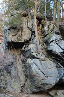
I featured Council Rock in a post a while ago, but Kali and I stopped by again late last Sunday afternoon.  The huge gneiss outcrop stands like a sentinel on the banks of the creek in the county park downstream of my natural area.  Local lore holds that Native American Lenni Lenape bands confabbed on or near the rock, hence its name.
Canada hemlocks cling to fractures in the tortured rock
A pair of Canada geese cruising upstream past the rock
Upstream view, late afternoon