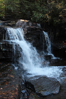
 |
| Jean's Run - downstream-most waterfall |
Nearly 20 years ago, I had completed a challenging circuit hike in the valley of Jean's Run near the town of Jim Thorpe, Pennsylvania. Jim Thorpe advertises itself as being in the Pocono Mountains, and it is near the Poconos, but technically it's in the folded terrain of the Ridge and Valley physiographic province, not on the flat but highly dissected Pocono Plateau. For the layman, these are minor points that would only interest a geology nerd. Suffice it to say the landscape is Appalachian.
Somehow I had stumbled on Jean's Run while I was hiking in the next watershed to the east: the valley of James's Run, which tumbles through an incredibly scenic and popular gorge called Glen Onoko. When I hiked up Jean's Run 20 years ago, the valley made a lasting impression on me. I recalled vividly that, midway up the valley, Jean's Run suddenly emerged from a narrow cleft in the rocks and tumbled over a dramatic waterfall that was barely passable.
Because I plan to move away from southeastern Pennsylvania in a few months, and because I wanted to challenge myself physically, and because I wanted to see the incredible waterfall again, I made the Jean's Run circuit my goal for the day.
The Jean's Run watershed is part of Pennsylvania State Game Lands 141, an area owned by the Pennsylvania Game Commission (PGC) and set aside for hunting (and other recreation). My route would take me eastward from the parking lot on a flat woods road maintained by the PGC along the top of Broad Mountain, and then along a woodland trail down the steep southern flank of the mountain to the mouth of Jean's Run. From that point, I planned to bushwhack northward back up the trackless Jean's Run valley to the PGC's woods road and then to the parking area where I left the car.
I knew the hike would be challenging. There's no trail along Jean's Run, and the valley is very, very steep and V-shaped, with rocks and boulders that have eroded out of the upper valley clogging the stream channel. I knew I would have to crisscross the stream repeatedly as I made my way uphill/upstream, but the autumn had been fairly dry so I wasn't concerned about the numerous stream crossings.
The top of Broad Mountain is flat, rocky, dry, exposed and infertile. As a result, the chestnut oak forest cloaking the mountaintop is open and stunted. My walk eastward along the PGC's woods road through this forest was a monotonous slog that I had to complete to get to the "good stuff," so I walked as quickly as I could. I only encountered birds (a small flock of Dark-eyed Juncos) at one spot. After about a half-hour, I reached the trail that descended to the mouth of Jean's Run.
 |
| Woodland trail descending to Jean's Run |
 |
| Stone ruin near stream's mouth |
 |
| Poured concrete dam |
 |
| Rocks and froth |
 |
| Lunchtime view |
 |
| Bracket fungi |
 |
| Red maple and shining firmoss |
 |
| Typical Pennsylvania mountain stream: boulders and rhododendrons |
My route up the valley to this point was almost directly northward. However, when I reached the spot I had remembered, the valley turned abruptly and Jean's Run began flowing from the west. The first part of my hike was bathed in bright sunlight, but the valley oriented to the west was in deep shadow - dark and mysterious - a valley that Victorian writers would call a "defile." And, at the mouth of the defile, there was not a narrow cleft in the rocks with a waterfall pouring forth like I had "remembered," but there was a huge vertical cliff on the southern side of the valley that had the effect of making the mouth of the defile look like a gateway into another world. Just inside the mouth of the gorge was a beautiful waterfall (first image in this post) - not as daunting or intimidating a barrier as I had remembered, but a beautiful introduction to a valley that was full of five dramatic waterfalls. The gorge was sublime.
(I would love to know the geologic origin of this valley. The gorge here, in addition to being oriented east-west instead of north-south, was also even steeper and more rocky than the valley further downstream - if that was possible.)
I enjoyed the view of the mouth of the gorge and then began my ascent. It was impossible to stay close to the stream here. The valley was simply too narrow and choked with boulders to navigate close to the water, so I had to make my way a few dozen feet above the stream along the valley slopes. Progress was extraordinary slow and footing was bad. But, every few hundred feet, there were waterfalls.
 |
| Second falls (counting upward from downstream) |
 |
| A splash of color in the dark and verdant ravine |
 |
| Third falls |
 |
| Fourth falls |
 |
| Fifth (uppermost and final) falls |
 |
| Pennsylvania Game Commission sign at road crossing |
I badly scraped my right shin, I scraped my back when I slid backward down a rock, I cut my forehead on a branch, and I wrenched my knees (already in poor condition) in so many ways I'm still trying to recover. I haven't decided if the trek was worth it, but I have decided that I'm officially old.


