Showing posts with label Capitol Reef national Park. Show all posts

Tuesday, July 20, 2010

Grand Wash, Capitol Reef National Park

Grand Wash (Note the hikers for scale)

Our stroll through Grand Wash was the last of our Capitol Reef National Park hikes. It was an easy walk, but the scale of the canyon was awe-inspiring. Grand Wash is only one of three canyons penetrating the Waterpocket Fold and, though it is almost flat, it was never used for transportation like the Fremont River canyon or the Capitol Gorge canyon because (1) it becomes too narrow in places, and (2) the mouth of the Grand Wash canyon disgorges into the Fremont River canyon, so why not just use the Fremont River canyon in the first place.


I really liked this formation, sort of a swirl of sandstone topped with a rock cherry.

Midway through the hike, at the Narrows, I suggested to my wife that she walk on to the mouth of Grand Wash and I would forego exploring the rest of the canyon, retrace my steps, get the car, and pick her up a the junction of the Grand Wash and the Fremont River canyon on UT 24. She agreed. As it turned out, we could probably have both completed the trail and retraced our steps since she arrived at the mouth of the canyon long before I did to pick her up.

More Moenkopi Formation spires and sunny composites

The Fremont River and domes opposite the mouth of the Grand Wash where I picked up my hiking partner.


Trying to maintain her stance and her hat in the gale-force wind, my wife stood stride the Velvet Cliffs Trail.

After we left the park, we had a few hours before dinner and decided to check out a trail along a cliff edge on BLM lands west of the town of Torrey, UT. The escarpment is known locally as the Velvet Cliffs. The trail is actually a sanctioned ATV/mountain biking/equestrian/hiking trail, so it's not in great condition. Nevertheless, we ascended the trail to the cliff top and walked for a short distance along the trail. We probably would have gone longer, but it was incredibly windy--so windy that it was difficult to stand. In addition, it was cold, and we weren't dressed for the weather.
An assortment of colors and textures atop the Velvet Cliffs

Fremont River Trail, Capitol Reef National Park


Riffle marks preserved in sandstone, Fremont River Trail

The last day of our stay in Capitol Reef National Park, we tackled two short hikes, the Fremont River Trail (this post) in the morning, and Grand Wash (next post) in the afternoon. The Fremont River Trail starts along the river then ascends steeply to the plateau overlooking the Fremont River canyon.

View of the mouth of the Fremont River canyon from the Fremont River Trail


An ancient Native American petroglyph?

Fremont River Trail on the plateau above the canyon


The Fremont River. We spent some time in this riparian zone watching Black Phoebes (Sayornis nigricans) hawking insects from streamside perches.

An orchard along the Fremont River.

When the area that is now Capitol Reef National Park was settled by Mormon pioneers, they planted many varieties of fruit trees and named their community Fruita (pronounced FRUIT-a). The National Park Service maintains the orchards, and encourages visitors to pick the fruit in season.

Thursday, July 15, 2010

Chimney Rock, Capitol Reef National Partk

Lichen encrusting a north-facing rock along the Chimney Rock Trail. This is the largest lichen I have ever seen--easily a foot across; I should have added an object for perspective.
Beginning of the Chimney Rock Trail. The snowcapped mountain in the background is the "Boulder Mountain" section of the Aquarius Plateau.

The Chimney Rock Trail is a 4-mile loop that climbs a series of steep switchbacks to the top of a plateau above the scenic Chimney Rock, and then winds through desert habitat. This was the most strenuous trail we attempted during our visit to Capitol Reef National Park. The only portion that was really strenuous was the climb up the switchbacks; once on top, the trail proved easy walking.
Chimney Rock, viewed from halfway to the top of the steep switchbacks.
Again, Boulder Mountain is visible in the background.
Mid-morning light is not particularly flattering
.
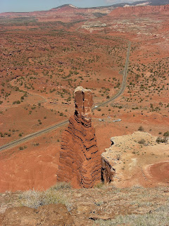
Looking down (and westward) onto Chimney Rock from the plateau above.
The road is UT 24, the main road through Capitol Reef
.
View east from the vantage point just above Chimney Rock. UT 24 is heading into the main part of Capitol Reef National Park, just around the bend.
View north from the Chimney Rock vantage point, with the Sulfur Creek Goosenecks in the foreground and "Boulder Mountain" in the back.
As were all the trails in Capitol Reef National Park when we visited in mid- to late-May, the desert was abloom along the Chimney Rock Trail.


Above is an image of the second of the two most wondrous plants I saw during my visit to southern Utah. I don't know if these plants have flowered, are yet to flower, or actually are in flower. I wonder if the swollen red neck at the top of the stalk is the plant's ovary? I stopped at the Capitol Reef Visitor Center after the walk to review their public herbarium collection, but three "stoners" were there discussing the virtues of Jimson weed, and I couldn't get access to the plant specimens without a prolonged wait.

Midway through the Chimney Rock hike, at the northernmost point of the loop, the trail intersects with an informal trail that leads through Spring Canyon. We walked a short distance downstream in beautiful Spring Canyon, but the bed of the wash became increasingly difficult to navigate because of huge boulder and tree trunk jams.
In Spring Canyon


Beginning the descent on the Chimney Rock Trail switchback, back to the trailhead.Chimney Rock in best light. The "rock" formed from erosion of the chocolate layer cake Moenkopi Formation.

Monday, July 12, 2010

Slickrock Divide and the Goosenecks, Capitol Reef

The Goosenecks meanders of Sulfur Creek

On the way out of Capitol Reef National Park following our day-trip through Capitol Gorge, I stopped to take some pictures at the Slickrock Divide, a minor watershed divide within the park.

Descending from the Slickrock Divide summit

The snowcapped Henry Mountains, a volcanic pile, are in the distance. I'd never heard of the Henrys before this trip, and now I want to explore there, too!


In the Slickrock Divide section of the park, the chocolate colored, strongly layered Moenkopi Formation has eroded into spires and hoodoos that I just couldn't stop photographing.
As in most other areas of the park, the wildflowers were blooming profusely here.


This was one of the two most wondrous plants I saw in the park. I don't know what it is, but the white scaffolding, which was probably last year's growth, seems to protect the new growth underneath.

After the Slickrock Divide, we spent an hour or so at a small turnoff called Panorama Point/Goosenecks Overlook. As Sulfur Creek enters the park from the west, it has cut a deep, meandered canyon into the Waterpocket Fold. Clearly, Sulfur Creek was flowing here as the Waterpocket Fold was uplifted, and it just incised its Goosenecks meanders deeper and deeper as the land rose higher and higher.We also took some photographs at Panorama Point. Doesn't every park have a Panorama Point?