Showing posts with label Schuylkill River. Show all posts

Thursday, November 13, 2014

Schuylkill Banks (Urban Hike)

Pierce Park skateboard daredevils  with Philadelphia Art Museum in background
Kali and I have walked the "natural areas" within easy striking distance of our house so many times we decided we needed a change of scenery.  So, last Sunday (November 9), I proposed an urban walk though central Philadelphia.  When I reminded Kali we could stop for a gelato midway through the walk, she was hooked.  (I got a double with grapefruit and dark chocolate, and Kali got chocolate and pistachio, by the way).

While I like our urban walks in general (I love to go downtown), I had an ulterior motive for this trek (other than gelato).  The city of Philadelphia is gradually constructing a recreational pathway alongside the Schuylkill River (the city's "western" river, as opposed to the much larger Delaware that flows along the city's east side).  The recreational path and associated green space is called the Schuylkill Banks and it is immensely popular with walkers, runners, bicyclists,  skaters, and skateboarders.

The easy parts of the trail have been built, but the city ran into a dilemma where a set of freight railroad tracks was located very close to the edge of the river.  The city's solution for continuing the trail in this location was to build the trail out into the river on concrete pylons anchored into the bedrock below the silt.  Because the Schuylkill is subject to flooding and bears lots of flood-borne debris, the structure had to be very sturdy but also aesthetically pleasing.  I think that the city and its design team succeeded masterfully.  The trail surface is poured concrete etched to look like wooden planks. 
Kali about to enter the over-water section of the trail
Detail of one of the handsome granite entrance posts to the over-water section
Another entrance post detail
The over-water trail at river level
The trail currently/temporarily ends at the South Street Bridge (yes, that South Street made famous in the pop song).  There were literally hordes of people on the bridge taking pictures very similar to the one below.  I had to jostle to the railing to get a shot.  The over-water section of the trail has only been open for about a month, so it's still drawing plenty of touristas - including Kali and me.  The view below filled me with civic pride and gratitude that we're living near a vibrant, exciting city.
View of the over-water trail and Philadelphia from the South Street Bridge
After we walked the Schuylkill Banks, we headed into the city for our gelato fix.  Our route back to our car took us past the Philadelphia Museum of Art, which has added a considerable number of contemporary sculptures to its grounds.  The piece on the left in the image below is called Symbiosis, and depicts (in gleaming stainless steel) a broken tree that has crashed into and is partially supported by a smaller neighboring tree.
Symbiosis (left) and another structure whose title I didn't notice

Monday, February 24, 2014

Winter Urban Hike

 
Although the weekend was very pleasant (clear, blue skies with temperatures in the mid-50s), the accumulated snow has by no means disappeared.  There's still a foot or more covering most unpaved, uncleared surfaces, and walking is extraordinarily difficult.  On Saturday, Kali and I walked at a state park with paved bicycle trails that had been plowed and were clear and dry, but unpaved, untreated trails were still snow-covered and icy.  So, we thought about other options for a long walk on Sunday and decided to tackle an 8-mile loop in Philadelphia.

The Schuylkill River (a bit of a redundancy, since the Dutch word Schuylkill means "hidden river," a name stemming from the fact the mouth of the river at the receiving stream [i.e., the Delaware River] was obscured by dense reed beds) forms the western edge of central Philadelphia.  The river flows within a large urban park created in the 19th century to protect water quality in a river that served as the source of the city's drinking water.  Today, roads parallel the river along both sides, but between the roads and the river runs a paved recreational trail that is very popular with walkers, runners, skaters, and bicyclists.  Because it was paved and had been plowed, the trail was clear and mostly dry, so Kali and I decided to walk from the north end on the western bank toward central Philadelphia, cross the river, walk back along eastern bank, and then cross the river again to our car - a total distance of 8 miles.

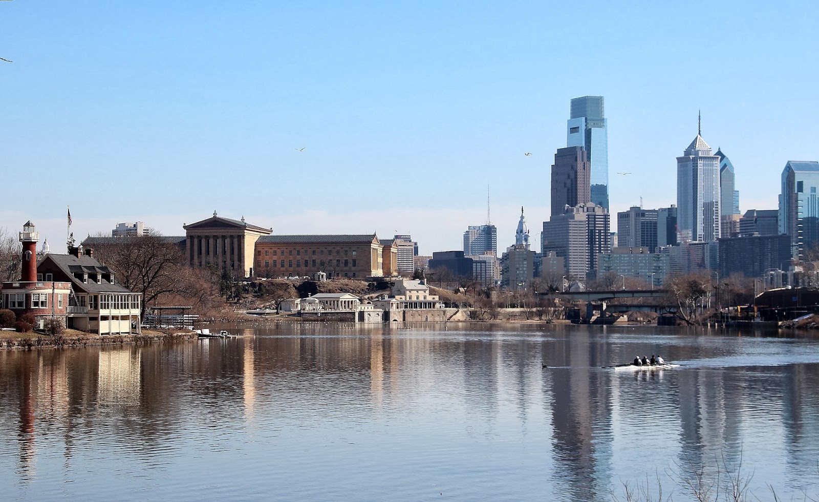
The image at the head of the post shows our approach to the southern end of the walk, nearing central Philadelphia.  The skyscrapers of Center City are at the right.  The large neo-Classical building on the left is the Philadelphia Museum of Art.  In the left foreground, along the river, are the clubhouses of the rowing clubs that use this stretch of the river for competitive training; this cluster of eccentric buildings is known as "Boathouse Row."  One of the clubs' teams is on the river in the right of the image.
Kali along the Schuylkill River esplanade
In the image above, Kali is standing at the rail above the Fairmount Dam, constructed to back up the river so that water could be withdrawn as a source of drinking water.  Behind Kali on the opposite bank of the river sits the Fairmount Water Works, completed in 1812.  The Water Works withdrew water from the river and pumped it to a reservoir on the hill above (Fair Mount), from which it was distributed throughout the city by gravity flow.  The Philadelphia Museum of Art now occupies the location of the reservoir.  The Water Works buildings have been rehabilitated and serve as an interpretive center for the city's water department.   

Fairmount Water Works and the Museum of Art
The Fairmount Dam also marks the head of tide in the Schuylkill River.  Downstream of this point, the Delaware River (and its tributary, the Schuylkill River) are tidal.  The image above was made at low tide, so some of the metamorphic rocks of the Piedmont are visible in the riverbed.  A very short distance downstream, the river crosses over onto the sandy Coastal Plain.
View northward across the top of the Water Works to Boathouse Row
The large house on the hill on the upper right of the image above is called Lemon Hill Mansion.  The area that is now parkland surrounding the river was once the private estates of wealthy Philadelphians who could afford to escape to their "country homes" instead of suffering through summer in the city.  All of the remaining mansions are now city-owned and are open to the public during the holidays when they are decorated for Christmas.
The recreation path in front of Boathouse Row
Looking Westward
This statue has always intrigued me.  Usually, I see it when I'm zipping past at 35 miles per hour on the road along the east bank of the river, but on Sunday Kali and I had a chance to look at it closely.  It was completed in 1966 by a Lithuanian sculptor and depicts an American pioneer carrying a caduceus gazing westward across an eagle's back.  It's dramatic and interesting, but so abstract it's hard to puzzle out.  My image isn't the best, but it's hard to interpret even when you're standing next to it.
Promontory Rock rock
At one point, the recreational trail enters a short tunnel bored through Promontory Rock formed from the hard metamorphic schist bedrock along the river.  My final image, above, shows the rock in detail - tortured, folded, melted and reformed during the collision of North America and Africa 200 million years ago.

Our 8-mile hike took us 2 hours and 23 minutes, including stops for images.  We ate lunch as we walked.

Monday, March 22, 2010

A Gardener's Gift

You would think, with the spectacular weather we had this weekend (cloudless skies and temperatures in the low 70s) that I'd have some wonderful images. But, no, just two mediocre ones.

First, the post title. The weather this weekend was the gardener's gift. I got my spring vegetables planted in my garden: spinach, lettuce, and two kinds of Swiss chard. (I started the "summer" vegetables last Sunday in a greenhouse.) Now, with rain today and cold temperatures forecast for the end of the week, the seeds are in place and on their own.

This Saturday, my wife and I walked six miles at Valley Forge National Historical Park. For those not familiar with Valley Forge, it obviously commemorates and hallows the ground where the Continental Army camped during the bitter winter of 1776, but it is also a recreation mecca for the Philadelphia area. And, understandably, it was packed with bicyclists (especially), joggers, and walkers this weekend. We chose a trail alongside the Schuylkill River, where I snapped the picture at the head of this post. The river had spilled out of its banks during the recent snowmelt and rain deluge; the floodplain was swept clear in many places, and buried in woody debris in others (as is visible in the foreground of the image above).

Along the walk, we encountered Virginia bluebells (Mertensia virginica) just emerging from the ground. In most places, the bluebells had to compete with the non-native lesser celandine (Ranunculus ficaria), as is apparent in the image below.
Sunday, I attended the memorial service for an acquaintance who had died of kidney cancer earlier this month. Afterward, with most of the day remaining, we took another long walk--this time at the natural area closest to home.