Showing posts with label southern Utah. Show all posts

Tuesday, July 6, 2010

Hickman Bridge, Capitol Reef

Western Tanager (Piranga ludoviciana) along the Fremont River
Capitol Reef National Park

Capitol Reef is the least visited of the six national parks in southern Utah. I don't understand why. Its scenery is as spectacular as the others, and it's located along Utah S.R. 12/24, which links Bryce Canyon to Arches and Canyonlands. The park's lack of popularity was fine with us, since it just meant the possibility of more serenity. While it wasn't a madhouse like Zion and Bryce can be, the park was hardly deserted.

The park was established mainly to protect the 100-mile-long Waterpocket Fold, a massive swell (monocline) in the earth's crust that formed while the Rocky Mountains were being uplifted. A monocline is a regional fold with one steep side in an area of otherwise nearly horizontal sedimentary layers; a monocline is a "step up" in the rock layers. Rock layers on the west side of the fold have been lifted 7,000 feet higher than those one the east side, but erosion over the last 20 million years has removed most of the uplifted rock so that the difference in the contemporary landscape is only several hundred feet between west and east. The Waterpocket Fold is the largest and longest monocline in North America and one of the largest in the world.
The Waterpocket Fold gots its name because it is a "fold" in the earth's crust, and because rainwater collects in sandstone basins in the rocks (i.e., waterpockets), creating pools that support wildlife throughout the year. The park's name comes from the fact that the Mormon pioneers who first visited the area thought that one of the eroded sandstone domes looked like the recently completed United States Capitol building in Washington, and the geologic formation, which formed a formidable barrier to east-west travel, resembled an ocean reef.
For our first day-hike in the park, we decided to tackle the Hickman Bridge Trail, the most popular in the park. The trail leads along the Fremont River, then heads into the hills above the river to Hickman Natural Bridge.
White sandstone, black basalt glacial erratics, and green grass along the trail to Hickman Bridge
Hickman Natural Bridge is visible from quite a distance away
After visiting the bridge, we retraced our steps down the trail and back along the Fremont River. In the riparian cottonwood trees along the river, we came across the very accommodating Western Tanager pictured at the beginning of this post. We saw quite a few Western Tanagers during our trip, but none that cooperated for a portrait like this one did.

Thursday, July 1, 2010

Notom-Bullfrog Road en route to Capitol Reef

Along the Notom-Bullfrog Road

Traveling from Boulder, Utah, and driving east, the Burr Trail Road crosses a low point in the Waterpocket Fold (more on that in the next post) and descends down a long series of steep switchbacks on a well-graded dirt road. The Utah guidebooks all made the switchbacks sound treacherous, and maybe they are in inclement weather, but I've driven on far worse flat and straight roads.

At the bottom of the switchbacks, the Burr Trail Road joins the Notom Road coming in from the north and the co-joined roads heads south to the Bullfrog marina on Lake Powell. Instead of heading south to Bullfrog, we turned north toward the ranching settlement of Notom (pronounced NOTE'm) and Capitol Reef National Park.

The Henry Mountains from the Notom-Bullfrog Road

The Notom Road is graded gravel for about 30 miles. To the west looms the Waterpocket Fold in Capitol Reef National Park; to the east, the still-snowy volcanic Henry Mountains are omnipresent in the distance. The first five or six miles crossed beautifully eroded mudstone and siltstone badlands; in places, the rock was variously shaded purple. Further north, though, the topography near the road became less interesting, but the roadsides featured plenty of wildflowers in spring bloom--my main motivation for driving the Notom Road.


Near Notom, the road approaches a photogenic sandstone butte before it joins Utah 24, the main east-west route through Capitol Reef National Park.

Wednesday, June 30, 2010

The Wash and Long Canyon Slot

Long Canyon Slot

Our fourth, and last, day hike in Grand Staircase-Escalante National Monument took us to The Wash and a nearby slot canyon branching off Long Canyon along the Burr Trail Road. It surprised me to see that there was a canyon called The Wash, since there are innumerable washes in this part of southern Utah. Why was this wash The Wash? We parked alongside the Burr Trail Road and decided to walk upstream because a camper told us that the canyon was difficult to navigate downstream (toward the Escalante River) after a distance because of rockfalls blocking the canyon. Unlike Deer Creek Canyon, which we explored the previous day, The Wash is fenced to keep cattle out. Equestrians still used the trail--and left plenty of road apples--but The Wash trail was so much more pleasant without the cattle.
A high bank and riparian vegetation in The Wash

Birding in The Wash

A huge cottonwood tree growing on a slope above the riparian zone

After lunch, we retraced our steps back to our vehicle and then drove a mile or so up Long Canyon to a slot in the canyon wall. Unlike the Dry Fork slots we visited on our first day in Grand Staircase-Escalante, the Long Canyon slot was short and never narrow enough to challenge our passage. It was beautiful nonetheless. A group of Buddhist monks who visit Boulder, Utah, each summer come to the slot to chant because of the great acoustics.

Align LeftThe entrance to the Long Canyon slot

Tuesday, June 29, 2010

Deer Creek Canyon

Last year's cottonwood leaf, bleached and papery

Our third day-hike in Grand Staircase-Escalante National Monument in southern Utah took us to Deer Creek Canyon, a short drive east of our lodging in Boulder, Utah, along the Burr Trail Road. Because it is a national monument and not a national park, and because they wanted to ruffle as few feathers as they could when they established the national monument by presidential proclamation, President Clinton and the Interior Department allowed considerable flexibility in land use within the monument--including continued grazing. Deer Creek Canyon is a poster child for overgrazing in the West. Though we actually never saw a live steer during our walk (we did see two carcasses), all edible vegetation had been nibbled to within an inch of its life, the landscape was strewn with cow pies, and countless cattle trails obscured the sandy, unmarked hiking trail. Deer Creek itself, in contrast to Calf Creek (our previous day's hike), is visibly more turbid and less appealing from cattle wallowing and runoff.

Nevertheless, the walk still offered some very pleasant scenery and some good opportunities for capturing images.
Natural desert gardens

A view upstream in the Deer Creek Canyon. Once the creek begins downcutting through the sandstone slickrock, it is confined to a deep ravine with a very narrow riparian corridor.

The view downstream as Deer Creek heads into its deep canyon en route to the Escalante River a few miles away. Deer Creek is one of the famous Escalanate Canyons "protected" in the national monument.

One of the features I found most interesting in the national monument (and adjacent Capitol Reef National Park) was the presence of what I later learned were glacial erratics. Boulder Mountain, to the north and west of the monument, contains a layer of volcanic basalt. During the Pleistocene glaciations, Boulder Mountain was topped with glaciers that flowed outward in all directions--including into the area currently occupied by the national monument. The glaciers carried volcanic boulders and deposited them on the desert landscape as the glaciers retreated. It's so incongruous to see rounded black boulders strewn over the stark, tawny sandstone slickrock.
Dead wood is carried onto the slickrock by summer storms, too.
This was the only rainy day during our eight-day stay in southern Utah. It provided for some interesting backgrounds. Sixty miles away, in Bryce Canyon National Park, it snowed!

Thursday, June 24, 2010

Lower Calf Creek Falls

A cluster of barrel cacti in bloom along the Lower Calf Creek Falls Trail

The 6-mile hike from the mouth of Calf Creek to Lower Calf Creek Falls and back is arguably the most popular hike in Grand Staircase-Escalante National Monument, and for good reason. The trail is relatively easy, with no significant gains or losses in elevation. The trailhead is located just off the main state highway (UT 12) through the monument, not 25 miles down a rutted dirt road like most of the hikes in the monument. The canyon scenery is superlative. And, there's running water year round--no small matter in this arid landscape.

The trail up Calf Creek Canyon

A desert garden. I didn't buy a wildflower guide, so I can't identify the plants--other than the prickly pear cactus (Opuntia spp.)


The riparian area along Calf Creek supports lots of birds, but none that we hadn't recorded on previous trips to Utah.Near the middle of the hike, Calf Creek's defined stream channel disappears into a series of wet meadows behind a succession of beaver dams. The lodge of one of the beavers is visible in the center lower right of this image.
Three species of trout inhabit Calf Creek, including the introduced European Brown Trout. I didn't try to identify the trout swimming in the crystalline water.Lower Calf Creek Falls
120 feet high

The trail ends at Lower Calf Creek Falls. When we visited in mid-May, the plunge pool was mercifully deserted, but I understand that the pool is a very popular and understandably irresistible attraction at the end of what must be a miserably hot hike in the middle of summer.

There's a second falls (Upper Calf Creek Falls) upstream of this waterfall. However, it has to be approached from above (not below) over a very steep slickrock trail marked with cairns. We didn't get a chance to visit the upper falls, but that leaves us something to discover on our next trip!

Wednesday, June 23, 2010

Devil's Garden

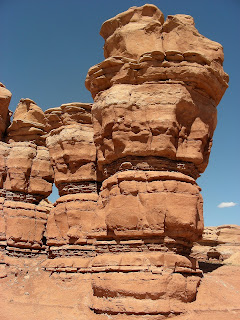
Hoodoos at Devil's Garden
Grand Staircase-Escalante National Monument, Utah

After we explored the slot canyons in Dry Fork Wash and were heading back toward Escalante, Utah along Hole-in-the-Rock Road, we stopped at the Devil's Garden, an area of fantastically weathered sandstone hoodoos.

An elegant natural bridge holding on by a "thread"

The hoodoos formed from differential erosion of three rock strata; the upper and lower rock layers were more resistant to erosion than the middle layer, yielding this garden of earthly delights. Enjoy!