Monday, February 24, 2014

Winter Urban Hike

 
Although the weekend was very pleasant (clear, blue skies with temperatures in the mid-50s), the accumulated snow has by no means disappeared.  There's still a foot or more covering most unpaved, uncleared surfaces, and walking is extraordinarily difficult.  On Saturday, Kali and I walked at a state park with paved bicycle trails that had been plowed and were clear and dry, but unpaved, untreated trails were still snow-covered and icy.  So, we thought about other options for a long walk on Sunday and decided to tackle an 8-mile loop in Philadelphia.

The Schuylkill River (a bit of a redundancy, since the Dutch word Schuylkill means "hidden river," a name stemming from the fact the mouth of the river at the receiving stream [i.e., the Delaware River] was obscured by dense reed beds) forms the western edge of central Philadelphia.  The river flows within a large urban park created in the 19th century to protect water quality in a river that served as the source of the city's drinking water.  Today, roads parallel the river along both sides, but between the roads and the river runs a paved recreational trail that is very popular with walkers, runners, skaters, and bicyclists.  Because it was paved and had been plowed, the trail was clear and mostly dry, so Kali and I decided to walk from the north end on the western bank toward central Philadelphia, cross the river, walk back along eastern bank, and then cross the river again to our car - a total distance of 8 miles.

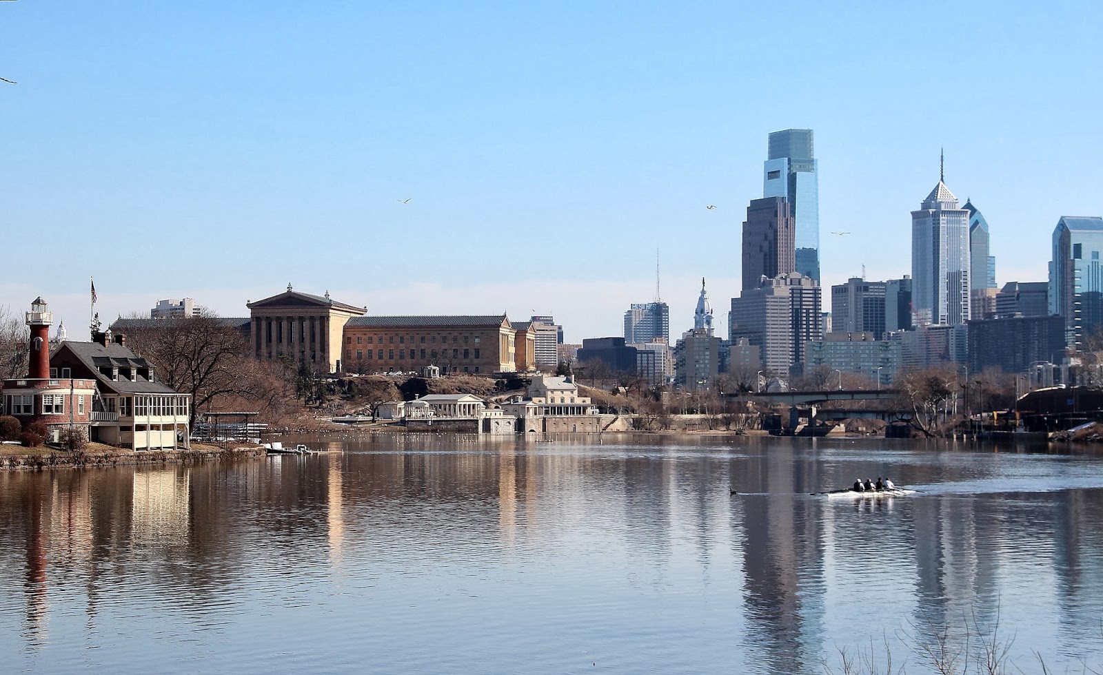
The image at the head of the post shows our approach to the southern end of the walk, nearing central Philadelphia.  The skyscrapers of Center City are at the right.  The large neo-Classical building on the left is the Philadelphia Museum of Art.  In the left foreground, along the river, are the clubhouses of the rowing clubs that use this stretch of the river for competitive training; this cluster of eccentric buildings is known as "Boathouse Row."  One of the clubs' teams is on the river in the right of the image.
Kali along the Schuylkill River esplanade
In the image above, Kali is standing at the rail above the Fairmount Dam, constructed to back up the river so that water could be withdrawn as a source of drinking water.  Behind Kali on the opposite bank of the river sits the Fairmount Water Works, completed in 1812.  The Water Works withdrew water from the river and pumped it to a reservoir on the hill above (Fair Mount), from which it was distributed throughout the city by gravity flow.  The Philadelphia Museum of Art now occupies the location of the reservoir.  The Water Works buildings have been rehabilitated and serve as an interpretive center for the city's water department.   

Fairmount Water Works and the Museum of Art
The Fairmount Dam also marks the head of tide in the Schuylkill River.  Downstream of this point, the Delaware River (and its tributary, the Schuylkill River) are tidal.  The image above was made at low tide, so some of the metamorphic rocks of the Piedmont are visible in the riverbed.  A very short distance downstream, the river crosses over onto the sandy Coastal Plain.
View northward across the top of the Water Works to Boathouse Row
The large house on the hill on the upper right of the image above is called Lemon Hill Mansion.  The area that is now parkland surrounding the river was once the private estates of wealthy Philadelphians who could afford to escape to their "country homes" instead of suffering through summer in the city.  All of the remaining mansions are now city-owned and are open to the public during the holidays when they are decorated for Christmas.
The recreation path in front of Boathouse Row
Looking Westward
This statue has always intrigued me.  Usually, I see it when I'm zipping past at 35 miles per hour on the road along the east bank of the river, but on Sunday Kali and I had a chance to look at it closely.  It was completed in 1966 by a Lithuanian sculptor and depicts an American pioneer carrying a caduceus gazing westward across an eagle's back.  It's dramatic and interesting, but so abstract it's hard to puzzle out.  My image isn't the best, but it's hard to interpret even when you're standing next to it.
Promontory Rock rock
At one point, the recreational trail enters a short tunnel bored through Promontory Rock formed from the hard metamorphic schist bedrock along the river.  My final image, above, shows the rock in detail - tortured, folded, melted and reformed during the collision of North America and Africa 200 million years ago.

Our 8-mile hike took us 2 hours and 23 minutes, including stops for images.  We ate lunch as we walked.

Wednesday, February 19, 2014

More Evidence of Hardship


Northern Mockingbird (Mimus polyglottos)
Although temperatures have begun to return to normal here in the northern Piedmont (average this time of year should be 44 degrees Fahrenheit), the ground is still covered with plenty of deep, crusty snow and the wildlife is desperate for food.

For the first time in the 26 years I have lived here, a Northern Mockingbird has begun to appear regularly at my suet feeder.  Mockingbirds, like American Robins, are insectivores during the warmer months, but switch to berries during the winter.  Clearly, the supply of edible, freeze-dried fruit on the vine has been exhausted and the mockingbird has turned to the only food it can find.

For so many of us, this winter can't end soon enough.

Friday, February 14, 2014

Will It Never End?

St. Valentine's Day dawn
My Western readers are probably tired of hearing about the snowy travails of us Easterners.  Well, we're tired of it, too.  The latest Mid-Atlantic Nor'easter dumped 11 inches of snow on my preserve from Wednesday evening into Thursday morning, then the precipitation changed to light rain and drizzle for the rest of the day, which made the snow heavy as lead.  Fortunately, the temperature stayed just above freezing, so the paved surfaces we cleared of snow stayed free of snow and ice all day.

Then, after dark (i.e., Thursday night into Friday morning) we got two more inches of snow, and the clearing started all over again on Friday morning.  The temperature in the wake of the storm got to around 40 degrees and skies were mostly sunny, so some paved surfaces even dried out.

This storm officially made this the 5th snowiest winter on record in the area.  And, guess what?  The forecasters are promising two-to-four more inches of snow for Saturday morning.  Our precipitation total for 2014 already is 40% above average.  
My back yard just after I shoveled the walk.  The snow mounds in the background are six feet high.
View to the (frozen) pond and beyond from my back door
Beckoning for a hike - on snowshoes!
Sweetgum (Liquidambar styraciflua) "balls" (fused seed capsules) against the morning sky
Kali and I are off to a concert by singer Martha Redbone in central Philadelphia tonight.  Thought we didn't plan it purposefully, the concert will be a nice way to celebrate St. Valentine's Day - and to take our minds off this seemingly endless winter.

Tuesday, February 11, 2014

Down to Seeds and Stems


We've had generous numbers of American Robins (Turdus migratorius) around my preserve all winter.  There are always robins here during the winter, but we seem to have more than the typical number this winter - despite the fact that there's more snow and longer-lasting snow cover than usual.

Because the snow has lasted so long, I (and other birders) have been wondering what the robins have been eating.  Though they are insectivores and carnivores during the growing season, they rely on fruits and berries during the winter.  However, they long ago stripped all the crabapple trees and holly shrubs of their berries.  What's left?

When Kali and I took a walk on Sunday afternoon, I noticed a small group of robins perched in a tree, flitting from branch to branch.  When I pulled up my camera with the telephoto lens, it became clear what was happening: the robins were eating fruits of invasive alien Asian bittersweet.

I knew that robins ate bittersweet arils (along with the berries of invasive Japanese honeysuckle and the hips of alien multiflora rose), which helps to spread the plants, but this is the first time I had seen them in action.  In addition, one of our strategies for managing our preserve is to try to eliminate as many of these alien plants as possible, so I feel a little guilty about reducing the winter birds' food sources.  On the other hand, the birds can always seek food in warmer climes, can't they...

The image above depicts an Eastern Bluebird (Sialia sialis) nesting box adorned with an icicle.  Bluebirds, also thrushes like robins, switch their diet in winter, too, and we host many bluebirds in the preserve as well.

Monday, February 10, 2014

Disconsolate

Edge Hill Road at the entrance to my preserve after the ice storm
My preserve was smack dab in the center of the recent Mid-Atlantic ice storm that caused 715,000 customers in the counties surrounding Philadelphia to lose electric power for days on end.  After an 8-inch snowfall Tuesday night into Wednesday morning (February 4-5), the precipitation changed to sleet, which coated everything and caused the havoc.  Our electric power went off at 4 a.m. Wednesday morning, and power was not restored until Sunday afternoon, February 9.  We were without heat, water, and lights for 105 hours.

Kali and I "camped out" in the living room near the wood stove for the duration.  We brought the two cats (who don't like one another) into the room with us, along with our parrot (in his cage, of course).  We all got as close to the stove as we dared.  Despite our tribulations, though, we had it better than many folks in the area because at least we had a stove and firewood; many other customers just shivered in their houses, some of which got down very near freezing day after day.

This storm was second only to Hurricane Sandy (August 2012) in terms of the number of electric customers affected.  Utility crews from all over the eastern United States and eastern Canada descended onto us in an effort to restore power.  Our service was restored by a crew from Georgia Power (who had just come from their own ice storm nightmare two weeks ago).
Some of the non-native firs and spruces in the preserve held up fairly well to snow cover

A white pine just inside our driveway that, like most of the white pines on the property, suffered many broken limbs
Having been largely housebound for nearly five days, Kali and I decided to walk two of the trails in the preserve on Sunday afternoon after the power was restored to get an idea of the damage.  It wasn't a pleasant walk because the snow was covered by a sheet of ice, which made walking very difficult.  In addition, the trails were interrupted end to end by downed branches, so we had to detour repeatedly.
A trail runs down the center of this allee of white pines
Kali detouring around a fallen tree blocking the trail
Though there was a lot of damage, whole topped trees like the fir in the image above were actually pretty uncommon - certainly far less common than they were in the wake of Hurricane Sandy.  Most of the woody debris consisted of large branches and limbs that cracked off the canopy of the trees, but the majority of the trees themselves were spared.

If storms like Hurricane Sandy and this ice storm continue to strike the preserve with regularity, there won't be anything left to preserve.  The trees will be damaged or killed, and then sunlight will stream into the woods and allow invasive vines to overwhelm the forest.  It's all very discouraging.