Detail of tree bark, Santa Margarita River Trail, Fallbrook Conservancy, CA
Several of my wife's and my family members live in San Diego County now, so I'm on the West Coast about once a year. Since we had been in southern Utah in May--two-thirds of the way to San Diego--we hopped a flight from Salt Lake City to San Diego for six days. Most of the time we visited with family, but we took two "natural" excursions to places we hadn't visited before, the tide pool at Point Loma on the ocean side of San Diego Bay and the Fallbrook Conservancy's Santa Margarita Preserve at the far northern edge of San Diego County, hard by Orange County.
Cockle shellsin the tide pools
We arrived at the tide pools at Point Loma at the maximum low tide, so we only had about 45 minutes to poke around in the pools before they were flooded again. There were lots and lots of anemones and hermit crabs to enjoy.
Yours truly (with splayed legs) observing up close
My brother-in-law (left) and I looking for crabs hiding in niches in the sedimentary cliff
Who's watching whom?
On our last day in California, my dad suggested that we go for a walk at the Fallbrook Conservancy's Santa Margarita River Preserve. The "river" (we East Coasters would have a hard time calling it even a creek, but it is a perennial stream and offers important riparian habitat) rises in the Cleveland National Forest in San Bernadino County, skirts the northern edge of San Diego County, and then enters Camp Pendleton Marine Corps Base before draining into the Pacific Ocean. It's a popular outdoor playground for rapidly developing northern San Diego County and southern Orange County. The day was hot, it was a Saturday, and quite a few folks took advantage of the river to cool off.
Santa Margarita River, Fallbrook Conservancy, Fallbrook, CA(I didn't notice my brother's arm pointing out a fish in the river until I posted this image.)
Santa Margarita River Trail, Fallbrook Conservancy
Santa Margarita River, Fallbrook Conservancy, CA Swimming optional
Oak clinging to the cliff for dear life
Along the Santa Margarita River Trail. A cannonball?
Our stroll through Grand Wash was the last of our Capitol Reef National Park hikes. It was an easy walk, but the scale of the canyon was awe-inspiring. Grand Wash is only one of three canyons penetrating the Waterpocket Fold and, though it is almost flat, it was never used for transportation like the Fremont River canyon or the Capitol Gorge canyon because (1) it becomes too narrow in places, and (2) the mouth of the Grand Wash canyon disgorges into the Fremont River canyon, so why not just use the Fremont River canyon in the first place.
I really liked this formation, sort of a swirl of sandstone topped with a rock cherry.
Midway through the hike, at the Narrows, I suggested to my wife that she walk on to the mouth of Grand Wash and I would forego exploring the rest of the canyon, retrace my steps, get the car, and pick her up a the junction of the Grand Wash and the Fremont River canyon on UT 24. She agreed. As it turned out, we could probably have both completed the trail and retraced our steps since she arrived at the mouth of the canyon long before I did to pick her up.
More Moenkopi Formation spires and sunny composites
The Fremont River and domes opposite the mouth of the Grand Wash where I picked up my hiking partner.
Trying to maintain her stance and her hat in the gale-force wind, my wife stood stride the Velvet Cliffs Trail.
After we left the park, we had a few hours before dinner and decided to check out a trail along a cliff edge on BLM lands west of the town of Torrey, UT. The escarpment is known locally as the Velvet Cliffs. The trail is actually a sanctioned ATV/mountain biking/equestrian/hiking trail, so it's not in great condition. Nevertheless, we ascended the trail to the cliff top and walked for a short distance along the trail. We probably would have gone longer, but it was incredibly windy--so windy that it was difficult to stand. In addition, it was cold, and we weren't dressed for the weather.
An assortment of colors and textures atop the Velvet Cliffs
Riffle marks preserved in sandstone, Fremont River Trail
The last day of our stay in Capitol Reef National Park, we tackled two short hikes, the Fremont River Trail (this post) in the morning, and Grand Wash (next post) in the afternoon. The Fremont River Trail starts along the river then ascends steeply to the plateau overlooking the Fremont River canyon.
View of the mouth of the Fremont River canyon from the Fremont River Trail
An ancient Native American petroglyph?
Fremont River Trail on the plateau above the canyon
The Fremont River. We spent some time in this riparian zone watching Black Phoebes (Sayornis nigricans) hawking insects from streamside perches.
An orchard along the Fremont River.
When the area that is now Capitol Reef National Park was settled by Mormon pioneers, they planted many varieties of fruit trees and named their community Fruita (pronounced FRUIT-a). The National Park Service maintains the orchards, and encourages visitors to pick the fruit in season.
Over a decade ago, an individuals with a house bordering a park downstream of the natural area that I haunt released some Wild Turkeys (Meleagris gallopavo). The turkeys became well established, flourished, and spread downstream and upstream into "my" natural area--and my back yard.
This year was a banner year for poults, and last month three prolific hens gathered their broods together for mutual protection and now patrol the natural area. The combined group appears almost nightly for a birdseed handout, and I'm most happy to oblige.In the wild, turkeys are wary and skittish; here, they are almost pets, though they draw the line at taking food from my hand. In my previous post, I featured a bright yellow slime mold that reappeared this summer in exactly the same spot on an oak stump where it gathered last summer. By nightfall last evening, only a few hours after I photographed it, the slime mold had ascended to the top of the stump and had reformed itself into what appeared to be a foamy, pale-pink crust. I'm watching for sporulating bodies, but have seen nothing yet.Stay tuned... This morning, going out for the newspaper, I noticed that Indian-pipes (Monotropa uniflora) had pushed up through the pine straw. I usually associate this saprophytic wildflower that gets its nutrients from mycorrhizal fungi with the autumn, but I'm probably thinking of saprophytic beechdrops (Epifagus virginiana) whose flowering structures often dry out and persist for long periods, becoming most obvious in the winter after leaf fall. My wildflower guide says that Indian-pipes bloom from June through August, so these are right on schedule.
Wood Turtle (Clemmys insculpta)
One of my neighbors sent me these images of a Wood Turtle (Clemmys insculpta) that her daughter found in the creek flowing through "my" natural area this spring. According to the natural area's naturalist, this is their first record of a Wood Turtle, though the species' range encompasses large parts of the northern Piedmont and well beyond. Either we're just too urbanized or no one has been observant enough to record the species before. Incidentally, my neighbor assured me that she and her daughter returned the turtle to exactly the same spot where they found it after they took these pictures in their back yard; I believe her.
In 2000, I attended the Society for Ecological Restoration's conference held in Liverpool, England that year. In the exhibitors' hall, I came across a display set up by Scotland's Borders Forest Trust (BFT), a non-profit organization that had just adopted a grassroots volunteer coalition called the Wildwood Group which had the audacious idea of re-creating a native forest in a valley that had been denuded and devastated by sheep and goats for centuries. Staffing the BFT's exhibit was Hugh Chalmers, whose title was Project Officer; Hugh was the on-the-ground man directly responsible for implementing the vision of the Wildwood Group. I was so captivated by Hugh's description of the project that (1) his inspiring vision literally choked me up as we were speaking, and (2) I sent BFT all of my remaining British pounds when I left England, and I have been a BFT member and supporter ever since.
In 2009, BFT published The Carrifran Wildwood Story, and I have prepared a review of the book that will appear in the journal Ecological Restoration. Here's a draft of my review.
The Carrifran Wildwood Story
Myrtle and Philip Ashmole, with members of the Wildwood Group.2009.Jedburgh, Scotland, UK: Borders Forest Trust.Paper, £15. ISBN 978-0-9534346-4-0. 224 pages.
What does it take to turn an ecologically “green desert” into a diverse, native deciduous forest—especially when the templates available to serve as guides are, at best, tiny ecosystem fragments with uncertain management and land use histories stretching back centuries?This was the daunting task faced by the all-volunteer Wildwood Group working in the harsh Southern Uplands of Scotland as they sought to acquire an entire watershed and “re-create…an extensive tract of mainly forested wilderness with most of the rich diversity of native species present in the area before human activities became dominant.”The Carrifran Wildwood Story, published to commemorate the tenth anniversary of the planting of the first trees on the site on New Year’s Day, 2000, in the “Millennium Grove” documents the project’s complete history from conception and land acquisition through the reforestation of nearly the entire 1,640 (665 ha) Carrifran Burn watershed.
The book is a popular (not scientific) account—highly readable, well-written, and lively.Nevertheless, the authors do not short-change the essential climatologic, edaphic, hydrologic, topographic, botanic and ethnographic characteristics of the region and the site that underpin the project.In this sense, the Wildwood Group’s planners were following the footsteps of visionary environmental landscape architect Ian McHarg (1969), who advocated for developing as thorough an understanding of a locale as possible prior to undertaking any action on the ground.
The book is divided into 12 roughly chronological chapters, each introduced by a brief outline of the topics addressed in the chapter.The first two chapters provide an overview of the conception of the project.The Wildwood Group visionaries imagined purchasing a small catchment whose native vegetation had been severely depleted by centuries of intensive sheep and goat grazing, and then restoring native forest to the watershed.The third and fourth chapters review the Wildwood Group’s five-year efforts to locate and raise money to purchase a suitable watershed—first in the Scottish Borders (the counties bordering England) and then, when a suitable site could not be located there, a bit further north in the Southern Uplands.A thorough and comprehensive overview of planning for the restoration, including evaluating the current conditions in the drainage, examining the prehistoric palynological record, and identifying contemporary woodland sites that could serve as models and sources of propagules for a re-created forestis the subject of chapters 5-7.The decade-long planting program carried out by forestry contractors and a large cadre of dedicated volunteers is covered in chapters 8-11.Finally, since forest restoration by its very nature requires centuries to complete, the twelfth chapter chronicles the encouraging short-term changes observed in the valley over the first decade and projects the site’s ecological trajectory into the future.
The Wildwood Group adopted the evocative name Carrifran Wildwood for their initiative.Carrifran, freely translated as “seat of ravens” or “raven’s crag,” has many local spellings and pronunciations, none of which, apparently, were the ones ultimately adopted by the Wildwood Group (which calls the valley CarriFRAN).Recognizing that readers outside Scotland may not be familiar with local topographic and geographic terms, the authors thoughtfully included a glossary of “descriptive words with various origins” on page 52, though the list is not comprehensive.For example, the authors frequently use the word cleugh but don’t define it (a cleft in a hill or a ravine).In addition, readers may want to keep a bookmark lodged between pages 68 and 69 to make frequent reference to the unfamiliar place names and planting sections shown on the excellent site map.
Among the facets of this project that struck me most strongly were the historic rights and privileges afforded the public with which the Wildwood Group had to contend.The Carrifran Wildwood was established on private property owned by the Borders Forest Trust (the official nonprofit entity that served as an umbrella group managing the Carrifran Wildwood as well as many community forestry projects).Nonetheless, the Wildwood Group had to confront issues that stand in stark contrast to the few constraints faced by restorationists working on private property in North America.For example, while the Wildwood Group always envisioned that “access will be open to all,” the group was forced to enclose the entire Carrifran watershed with perimeter fencing to exclude wild roe deer, domestic sheep, and feral goats.In the process of protecting the newly planted trees, the fence excluded “hillwalkers”—hikers who enjoy the privilege of traipsing freely over private property throughout Britain.In addition, once the fence was in place, the Group had to remove the feral goats that roamed throughout the hills.The rural residents of the Southern Uplands expected to encounter goats, and their exclusion from the Wildwood through a combination of live capture and relocation and (in the case of a few highly elusive individuals) lethal sharpshooting, proved controversial.In his Foreword to the book, Professor Aubrey Manning notes that,“…it must have been very demanding of the tolerance and forbearance of the local people, of planners and statutory bodies like Scottish National Heritage and the Forestry Commission and of charitable trusts.A lot of persistent persuasion will have been involved and this story is set out here in a fascinating way” (page 3).
Excluding hikers with a fence would cause few problems in North America; in fact, hikers here need to secure permission before entering private property.Similarly, in most cases, North American landowners have the right to control feral animals on their own property and also may be able to control wild populations like deer if landowners can document that the animals are causing economic loss or hardship.
Another difference between the restoration efforts at Carrifran and those in many parts of temperate North America was the lack of non-native invasive plant species that needed to be managed in the Scottish project.To be sure, the trees planted at Carrifran had to compete with dense patches of native bracken fern (Pteridium aquilinum), which the Wildwood Group was forced to manage mechanically and chemically.Forest restorationists working in eastern North American woodlands with very high white-tailed deer densities often must contend with a similar situation when the ground layer vegetation has been decimated by browsing, leaving only a dense cover of unpalatable hay-scented ferns (Dennstaedtia punctilobula). However, the absence of the fast growing introduced vines, lianas, and shrubs that can overtop saplings planted in eastern North America during a single growing season made me almost wish that bracken was my greatest challenge in establishing new woodland.
The book is thoughtfully designed and visually appealing.The designer restricted the text to two-thirds of each page, and then devoted the remainder of the page to full-color photographs, maps, and blue-background sidebars that explore the details of subjects mentioned in the accompanying text.The sidebars also occasionally contain poetry, evocative watercolor reproductions, and anecdotes and testimonials contributed by Wildwood Group members who were integral to the project’s success.
The book will appeal most directly to deciduous forest restorationists working in the temperate zones.However, the detailed account of the ecological planning that took place before a single tree was introduced onto the site should be of interest to all restorationists.And, those of us who fancy ourselves to be stewards of the earth will find ample inspiration in the audacity and execution of this truly visionary project.
Reference
McHarg, I. L.1969.Design with nature. Philadelphia: The Falcon Press.
Lichen encrusting a north-facing rock along the Chimney Rock Trail.This is the largest lichen I have ever seen--easily a foot across; I should have added an object for perspective. Beginning of the Chimney Rock Trail. The snowcapped mountain in the background is the "Boulder Mountain" section of the Aquarius Plateau.
The Chimney Rock Trail is a 4-mile loop that climbs a series of steep switchbacks to the top of a plateau above the scenic Chimney Rock, and then winds through desert habitat. This was the most strenuous trail we attempted during our visit to Capitol Reef National Park. The only portion that was really strenuous was the climb up the switchbacks; once on top, the trail proved easy walking.
Chimney Rock, viewed from halfway to the top of the steep switchbacks. Again, Boulder Mountain is visible in the background. Mid-morning light is not particularly flattering. Looking down (and westward) onto Chimney Rock from the plateau above. The road is UT 24, the main road through Capitol Reef.
View east from the vantage point just above Chimney Rock. UT 24 is heading into the main part of Capitol Reef National Park, just around the bend. View north from the Chimney Rock vantage point, with the Sulfur Creek Goosenecks in the foreground and "Boulder Mountain" in the back.
As were all the trails in Capitol Reef National Park when we visited in mid- to late-May, the desert was abloom along the Chimney Rock Trail.
Above is an image of the second of the two most wondrous plants I saw during my visit to southern Utah. I don't know if these plants have flowered, are yet to flower, or actually are in flower. I wonder if the swollen red neck at the top of the stalk is the plant's ovary? I stopped at the Capitol Reef Visitor Center after the walk to review their public herbarium collection, but three "stoners" were there discussing the virtues of Jimson weed, and I couldn't get access to the plant specimens without a prolonged wait.
Midway through the Chimney Rock hike, at the northernmost point of the loop, the trail intersects with an informal trail that leads through Spring Canyon. We walked a short distance downstream in beautiful Spring Canyon, but the bed of the wash became increasingly difficult to navigate because of huge boulder and tree trunk jams.
In Spring Canyon
Beginning the descent on the Chimney Rock Trail switchback, back to the trailhead.Chimney Rock in best light.The "rock" formed from erosion of the chocolate layer cake Moenkopi Formation.
I earned an advanced degree in ecology and held a professional position related to forest ecosystem restoration. I retired from my position in 2018 and moved from the Mid-Atlantic to the Front Range of the Rocky Mountains in Colorado.

 Detail of tree bark, Santa Margarita River Trail, Fallbrook Conservancy, CA
 Cockle shells in the tide pools
 Yours truly (with splayed legs) observing up close
 My brother-in-law (left) and I looking for crabs hiding in niches in the sedimentary cliff
 Who's watching whom?
 Santa Margarita River, Fallbrook Conservancy, Fallbrook, CA (I didn't notice my brother's arm pointing out a fish in the river until I posted this image.)
 Santa Margarita River Trail, Fallbrook Conservancy
 Santa Margarita River, Fallbrook Conservancy, CA
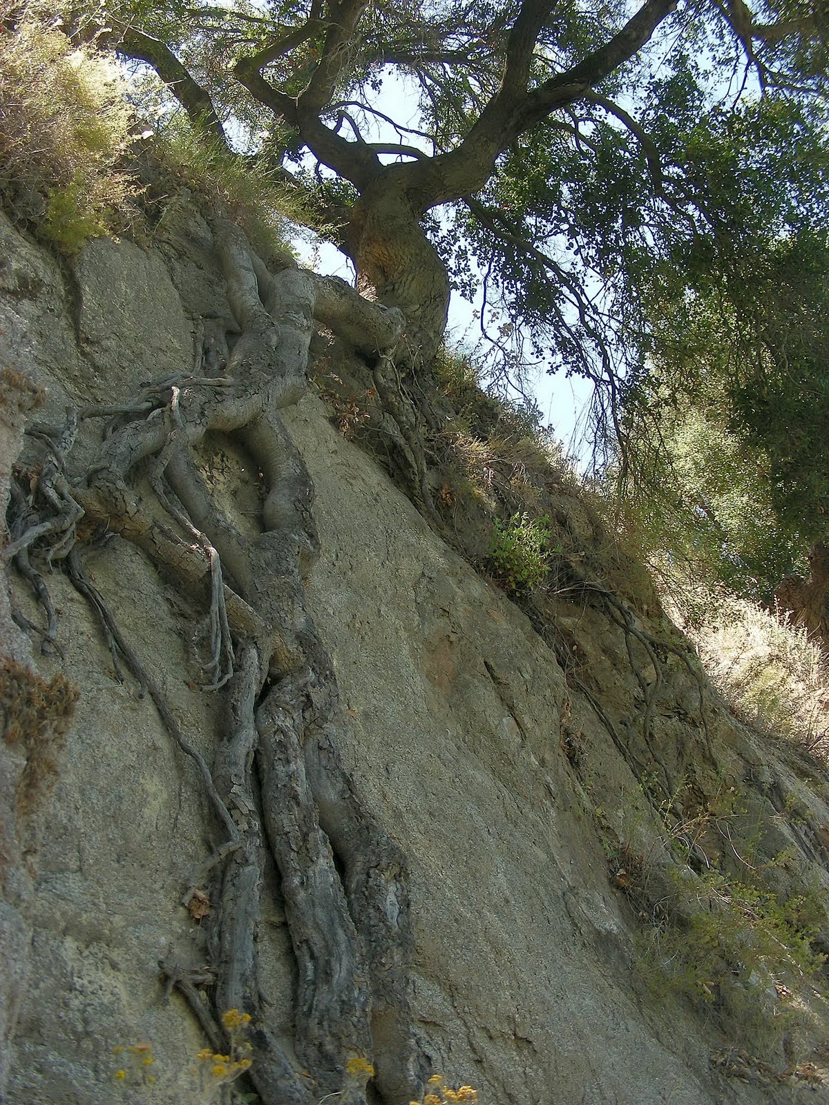 Oak clinging to the cliff for dear life
 Along the Santa Margarita River Trail. A cannonball?


