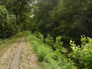
 Though I love to ride my bicycle, many things conspired this summer to limit my rides--especially the relentless string of humid, 90+ days. My wife had to work all day last Saturday (August 21), so she suggested that I go for a long ride that day. Just recently, the Pennsylvania Department of Conservation and Natural Resources announced that it had repaired and reopened the towpath paralleling the Delaware Canal following devastating flooding in 2006. The ride along the towpath had been among our favorite rides before the flooding destroyed the trail, so I took advantage of the fact that the towpath had just reopened to take a 36-mile ride on Saturday morning (18 miles out and back). The entire trail runs from Bristol, Pennsylvania on the south to Easton, Pennsylvania on the north, a distance of 59 miles. For most of its route, the Delaware Canal closely parallels the Delaware River.
 The canal was severely damaged by flooding in June 2006. The Delaware River rose up out of its banks, inundated the canal, and scoured away the towpath in many places. The state vowed to repair the trail, and they finally came through after four years. How long will it last, though? There are "high water marks" on buildings, rocks, and bridge abutments all along the towpath, and all of the marks are above the level of the canal.
The canal and towpath traverse some pretty scenic landscapes. Nowadays, of course, the properties are among the most expensive in Pennsylvania because of the corridor's rural character, its proximity to New York City and Philadelphia, and the spectacular views across the canal and the river.
There are quite a few historic structures still extant, dating from the canal's heyday (1832-1931). The following are views of the Uhlerstown Covered Bridge spanning the canal.
 A red-girt bridge spanning the canal; there are literally hundreds of of these ubiquitous bridges along the towpath
The canal also supported plenty of inns along its route; many are still bed-and-breakfasts and restaurants.
 Indian Rock Inn
 Lumberville Inn
The canal was largely built on the floodplain of the Delaware River, so it intersected with many riparian features. Much of the canal corridor is wooded and semi-natural, making for a very pleasant bike ride. Of course, with the area so frequently disturbed, invasives are a big problem.
But many areas are more natural, especially where the canal cuts through backwater swamps.


 While the canal was dewatered for four years for repairs, sycamore seedlings established themselves. Now that the canal has been reflooded, I wonder if these trees will be able to persist, even though they can tolerate some wet feet.
At Mile 46 (north of the southern terminus), sheer 300-foot cliffs rise up above the south side of the canal and the Delaware River. These are the Nockamixon Cliffs (also sometimes called the Delaware River Palisades). The red shales and sandstones that were originally deposited here were cooked into hard metamorphic hornfels by a nearby magmatic intrusion, making the rock extremely resistant to erosion.
Fifteen thousand years ago, when glacial ice dominated the landscape just a few miles north, arctic conditions prevailed on the cliffs. Today, a remnant of those times persists on these north-facing, cooler, and moister rock walls. Roseroot sedum (Sedum rosea), a plant usually found in arctic or high mountain areas, is an endangered species in Pennsylvania known only from two sites along the Delaware River. it was discovered growing on the Nockamixon Cliffs in 1867. Since then, the cliffs have been regarded as one of the most important botanical areas in southeastern Pennsylvania. The cliffs are off-limits to the public, and are virtually inaccessible without technical climbing gear.


No comments:
Post a Comment