Wednesday, July 29, 2009

Midwestern Memories

Wolf Creek Falls

I just returned from six days in northeastern Ohio, the area where I lived until I was 18 years old and where, until recently, most of my immediate family lived. Now, my youngest siblings have moved to the outer suburbs of Cleveland or to San Diego, California, but I needed to visit my elderly mother-in-law, who lives alone in one of the inner ring suburbs.

I decided to drive instead of fly because air fares were high. There's almost no competition between airlines for service between my home city and Cleveland; hence, there's no price competition, either. So, I made the 8-hour trip by car.

As I approached the Cleveland metropolitan area on the freeway, I started to get nostalgic pangs. The area was very important during my formative years, and it still has a grip on me, albeit one that becomes increasingly tenuous with each passing year. Part of the reason for its slipping away is that, when I visit natural places that were important when I was growing up, most have shrunken as a result of suburban development or, worse yet, have disappeared altogether. Thus, the "place" doesn't have the hold on me that it once did.

Most of the time in the Cleveland area I spent working on my mother-in-law's house, but I did escape twice--once to one of the wonderful Cleveland Metroparks, and once to a natural area owned by The Holden Arboretum in the far eastern suburb of Kirtland.

Wolf Creek Falls from above

The first site I visited was the Garfield Park Reservation of the Metroparks system. It's neither one of the larger nor one of the more interesting parks, but it was nearby and accessible. Its system of carriage roads was designed by Olmstead and Vaux (of Central park fame). Naturally, I gravitated to water, which, in Garfield Park Reservation, is either uninteresting and filthy Mill Creek or its more scenic tributary, Wolf Creek.

Wolf Creek, too, has always been a sewer--even 45 years ago when I first started to visit the park. It emerged from a big pipe where the stream had been buried in the newly-developed suburbs and was foul from its headwaters. Undoubtedly, sanitary sewer cross connections polluted the water. Despite its poor water quality, though, where the creek entered Garfield Park it flowed over hard, slick bluestone that created a fabulous slippery channel for several hundred feet before the water poured over a falls into a large plunge pool below. I can't begin to estimate how many times in the summer I "skated" along the streambed in bare feet up to the very brink of the cascade. Water quality hasn't improved any, but the creek is still amazingly beautiful.

One of the many crevasses on Little Mountain

For the second escape, I accompanied two docents who led a group of twelve walkers to Little Mountain, one of the natural areas protected by The Holden Arboretum. I would have liked to visit Stebbin's Gulch (another of the arboretum's natural areas, and one that has been called "the most sublime natural area in northern Ohio" [I agree]), but all visits to Holden's natural areas are by guided walks, and the Stebbin's Gulch tour was not scheduled for the time I was in northeast Ohio. So, it was off to Little Mountain, a natural area I had never previously visited.

Little Mountain is a high point in northeastern Ohio's glaciated landscape--hardly a mountain. It is capped with an erosion-resistant rock called Sharon Conglomerate. The conglomerate has a tendency to develop cracks that frost, rain, and ice erode into deep, vertical crevasses. Despite the fact that the crest of Little Mountain was the site of several successive hotel complexes that operated until the early 1900s, there is virtually no evidence of the resorts-- just a mature forest of Canada hemlocks and white pines mixed in with some yellow birch and oaks. A good afternoon walk.
Thursday, July 16, 2009

A Mid-Atlantic Midsummer's Night's Sights


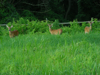
Two images of does browsing on shrubs at the edge of high grass that I captured last evening on a walk through my favorite local natural area. The area's deer population is far above carrying capacity, so I see deer inordinately frequently.

This is an image of a fallen limb at the edge of a wetland at the natural area. I like this reflected image and have intended to photograph it for several weeks. Unfortunately, the image would be a lot clearer if (1) I had a higher-quality camera and/or (2) the limb weren't lodged in the mud on the far side of the wetland. This limb frequently serves as a perch for Green Herons (Butorides striatus), which successfully fledged a brood in the trees surrounding the wetland earlier this summer.

This wetland has been colonized by a beaver (Castor canadensis) within the last three weeks--an amazing occurrence since the natural area is embedded in densely developed suburbs. When I visit just before dusk, which is when I took this image, the beaver is usually making a v-shaped wake as it cruises across the wetland. No beaver last night, although there was a group of skittish Wood Ducks (Aix sponsa) plying the waters--a mother with four adolescents in tow.

Zuni Turkey Fetishes


Three of the Zuni turkey fetishes that we bought when we visited Gallup and the Zuni Pueblo in May 2009. Turkeys have become our real focus when we shop for native crafts, antiques, and artwork. This passion stemmed from the fact that farm-raised Wild Turkeys were released into a county park near our home and established large, self-sustaining populations in our neighborhood. They're magnificent birds and we enjoy all of the nuances that artists incorporate into their artwork. In fact, they're so dramatic, we can't believe that every artist who uses natural themes in their work doesn't take advantage of turkeys' coloring, shape, and behavior.

Wednesday, July 15, 2009

Straddling the Continental Divide: Western New Mexico, May 2009 (IV)

Cactus on the Narrows Rim Trail

El Malpais National Monument and National Conservation Area

On the fourth day of our trip to northwest New Mexico (Saturday, May 16, 2009), we decided to visit El Malpais National Monument and National Conservation Area south of Grants. El Malpais ("the badlands" in Spanish) are an area flooded just 2,000-3,000 years ago by lava flowing out of McCarty's Crater. Its volcanic features include jagged spatter cones, a lava tube system extending at least 17 miles, fragile ice caves, and a miles-long line of cinder cones that developed where the earth split and allowed ash and cinders to erupt into the air. We decided to make a loop, following NM 117 south from Grants, then heading back north on Cibola County Road 42 (The Chain of Craters Backcountry Byway) and finally returning to Grants via NM 53.

Our first stop (after visiting the excellent and helpful BLM/NPS/Forest Service Northwest New Mexico Visitors' Center along I-40 on the outskirts of Grants [a really hot young guy and his dad came in while we were there] was La Ventana Natural Arch along NM 117. La Ventana, the largest of New Mexico's easily reached natural arches, was eroded from standstone dating back to the Cretaceous Era.

La Ventana Natural Arch

From La Ventana, we continued south on NM 117 to the Narrows and the Narrows Rim Trail. Here, the lava from McCarty's Crater flowed almost--but not quite completely--up to the base of the same 500-foot-high sandstone cliffs from which the arch was eroded. The highway threads through the narrow corridor between the jagged lava flow and the cliff base--hence the name. We parked at the Narrows Rim Trail parking area, had lunch, then ascended to the top of the cliffs where we were treated to spectacular views across the lava fields to the chain of cinder cones in the distance, and, closer up, to a profusion of cacti blooming everywhere.

Cacti along the Narrows Rim Trail

Overlooking the lava flows from the Narrows Rim Trail

We descended from the trail, then hopped back in the car. By now, the sky had begun to cloud up as we headed further south to the Lava Falls Area where the National Park Service has created a self-guiding nature trail through the lava flow. The route is marked with tall lava rock cairns, but it's difficult to follow and the surfaces are uneven and jagged. Don't trip! Nevertheless, we completed the circuit in about an hour and enjoyed the landscape.


Collapsed lava bubble, Lava Falls Area

Detail of lava, Laval Falls Area
From Lava Falls, we had two options: we could continue to make the loop on the Chain of Craters Backcountry Byway, or we could retrace our route north back to Grants. It was early afternoon, so we decided to try the Chain of Craters road.

This decision was a minor mistake. The road is a dirt track that is probably passable by a passenger vehicle (we had an SUV), but it wouldn't be a pleasant ride in any kind of vehicle. It's rutted, rocky, dusty and very uneven--much like the road to Chaco, but twice as long. Plus, the scenery is not spectacular and doesn't change much. The road passes close to only one of the cinder cones; the rest are all a mile or so in the distance and on private property. Cattle--numerous cattle--roam everywhere, mostly on the road and through ugly, overgrazed range. In retrospect, I'd skip this "backcountry byway," which took about 2 hours of white-knuckle driving to complete. (Our host at our Thoreau bed-and-breakfast had never driven the road despite having lived in the area for 20 years.)

As we approached paved NM 53, I had wanted to stop at the Big Tubes lava caves area, but the caves were 5 miles from the main road on more dirt road (!)--too far to drive so late in the day--so we passed them up. We finally reached NM 53 and headed back to Grants. Along the way, we stopped at El Calderon area for a half hour where there is an easily accessible lava cave, plus two deep, sheer-sided and gigantic lava sinkholes.

By then, it was getting late, a thunderstorm was immenent, and we were tired, so we headed back to Thoreau for our last evening in northwest New Mexico.

Wednesday, July 8, 2009

Straddling the Continental Divide: Western New Mexico, May 2009 (III)

El Morro National Monument
Zuni Pueblo

On our third full day in northwestern New Mexico, May 15, 2009, we decided to drive "The Loop," a 100-mile plus circular route from Gallup south to Zuni Pueblo, then eastward past El Morro National Monument and El Malpais National Monument to Grants, then back to Gallup (or, in our case, Thoreau) via I-40.

I didn't take any pictures in Zuni Pueblo. Photographs of ceremonies are strictly forbidden, but I didn't want to push my luck by taking photographs in town. And, frankly, there's not much to photograph, anyway; Zuni Pueblo just looks like a small, rural town with contemporary housing and a fairly prosperous-looking main street catering mostly to tourists.

What did strike me is that the town is very, very dusty. Everything is coated with red dust. It was windy the day we visited, so the dust was swirling everywhere. Our first stop was the Zuni-operated craft cooperative, and I remarked to the woman who was helping us that "everything's red!"; she agreed with me, and said the dust settled down somewhat in July and August during the monsoon season. At the co-op, my wife bought some earrings and together we bought some fetishes.

We drove down the street to several Indian craft emporia where I bought a Zuni turquoise bracelet and we bought several more fetishes; Zuni had the best quality and best selection of Zuni fetishes that we had seen in New Mexico.

One thing that struck me as a bit odd was that several of the craft stores (both in Zuni and in Gallup) were owned by Muslims. I don't have anything against Muslims; it just struck me as strange that so many Muslims would have located stores in northwestern New Mexico, for goodness sake. (I mentioned this to our innkeeper, and he informed me that the Muslim community was robust and was not new to the area. They had established their stores well over 40 years ago.)

Since most of the stores (other than the co-op) were owned by Muslims, and by then it was approaching noon on Friday (time for prayers), the stores were all closing. We headed east to El Morro National Monument.

El Morro National Monument

El Morro is one of the 10 least-visited units of the National Park Service--probably because it is really off the beaten track. Nevertheless, we found it to be one of our favorite stops during our entire vacation. It has beautiful scenery, nice walking trails, an interesting hiking trail, Anasazi ruins, and colonial and contemporary history ranging from the 16th to the 21st century.

After paying our admission fee ($3/person), we had lunch in the shady picnic area and then set out to explore. Our first stop was the permanent pool of water at the base of Inscription Rock. This is pool was what drew people to El Morro and Inscription Rock in the first place; it was the only reliable source of water for many, many miles in any direction, so it attracted Native Americans, Spanish conquistadors and missionaries, and settlers traveling overland to the West. The pool is not spring fed; it collects water in a large, shady niche from the summer monsoons and from the infrequent storms during the rest of the year.

Permanent pool at base of Inscription Rock
Note spill-off from atop El Morro

We continued our exploration by rounding the northern and western sides of Inscription Rock, a portion of the El Morro massif with relatively flat sandstone surfaces that fairly beg for graffiti. There are inscriptions here from ancient Anasazi visitors all the way up to the visitors in the early part of the 20th century. Most of the inscriptions seem to have been made by Spaniard explorers and missionaries in the 1700s, and most are still highly legible. Many years ago, the superintendent of the site ordered that the inscriptions added to the rock after the site was protected by the National Park Service be erased; many were removed, but a few still remain.
One of thousands of inscription on Inscription Rock

The inscriptions peter out on the south side of the rock, but that's where the trail that climbs 200 feet to the top of El Morro begins. (El Morro, by the way, means "headland" in Spanish because the rock rises straight up out of the surrounding plain.) We hiked to the top of the rock, where the surface has been eroded into large, pillow-shaped formations separated by cracks and erosion rills. The center (eastern) side of El Morro is a beautiful box canyon, and the trail skirts the rim of the box canyon on one side and the edge of Inscription Rock on the other. The trail was fun and challenging.

Central box canyon (view eastward) from top of El Morro


Anasazi ruins perched atop El Morro
(Note smoke from controlled burn in distance on Zuni Mountain, Cibola National Forest)

Near the end of the trail atop El Morro are the remains of an Anasazi pueblo. How the heck did these folks get water for their settlement on a routine basis? What a pain in the neck if they had to climb down to the water hole at the base of the cliff all the time.

Inscription Rock viewed from atop El Morro (controlled burn visible in distance)

The trail down from the top of the rock afforded great views to the west and south of the Inscritpion Rock portion of El Morro. The trail descended from the heights via a dirt pathway interspersed with three sets of metal stairs. When we reached the bottom, we traveled back to the Visitors' Center where I completed a vistors' survey. Then, we drove on to Grants, where she shopped for some toiletries and refilled our rental SUV's gas tank.

Tuesday, July 7, 2009

Summer Perfection

Last Friday evening, July 3, 2009, was absolutely perfect in my corner of the Mid-Atlantic. After dinner, my wife and I went for an early-evening walk in the natural area nearby. The sun was getting low on the horizon and it imbued the tall grasses along the trail with gold brilliance (not nearly adequately captured in my image here). There was a steady breeze, humidity was low, and the temperature was about 70 degrees (70 degrees on July 3!). Off to the southeast, a 2/3-full moon was rising, and bats were beginning to patrol the skies just a few feet above our heads.

Why can't all of summer be just like this heavenly evening?

Friday, July 3, 2009

Farmworker (for half a day)

Volunteers preparing harvested vegetables for distribution at the CSA

We spent this morning at the organic Community Supported Agriculture (CSA) farm to which we belong. It was a perfect day to put in our required minimum four hours of volunteer labor for the year--mostly cloudy and in the low 70s.


The farmer gave us our assignment when we arrived: he asked us to clear mile-a-minute vines (Polygonum perfoliatum) off a pile of highly composed leaf mulch that the farm uses for fertilizer and soil conditioner. Mile-a-minute, for those of you who don't know it, is a highly invasive nonnative vine that grows like crazy during the summer (hence its name). It was introduced from Asia in the 1940s, hitchhiking on the root ball of imported rhododendrons. Since then, it has spread insidiously throughout the East Coast. It's got tiny little recurved (i.e., facing backward) barbs along its stem that make the use of gloves mandatory.

The compost pile was also covered with Canada thistle (another nasty plant imported from overseas--not from our neighbor to the North, as its common name would suggest). So, we spent the next two hours hand-pulling the mile-a-minute and the thistle until the pile was cleared off, we were tired and drenched in sweat, and our legs and arms were itching with contact dermatitis.

After our work was completed, we had an opportunity to pick-up our food share for the week: kale, green beans, kohlrabi, Swiss chard, lettuce, and cucumbers.

Wednesday, July 1, 2009

Straddling the Continental Divide: Western New Mexico, May 2009 (II)

Zuni turquoise bracelet and and lapiz and turquoise ring

Shopping in Gallup

Another of our goals for coming to Indian Country, New Mexico, was to shop for Native American jewelry, crafts, and pottery in Gallup and Zuni. So, on our second full day in New Mexico, we set off for Gallup.

Bob, our host at the Zuni Mountain Lodge, suggested that we begin our shopping at Joe Milo's Trading Company on NM 602 south of Gallup. He told us that Milo's has good quality and fair prices, so off we drove.

As it turns out, Milo's probably does have perhaps the best selection and fairest prices of all the emporia in the area. My wife bought a Zuni bracelet and matching earrings there. But, we had yet to peruse downtown Gallup, whose main street is lined with Indian goods stores, so we set off back north into town.

We spent the rest of the morning (and into the early afternoon) walking from shop to shop in downtown Gallup looking for jewelry, pottery, and Zuni fetishes that interested us. The famous Richardson's store had good quality merchandise, but its size and stock are overwhelming and we didn't buy anything there. We did buy several turkey fetishes (our special interest) and several other pieces of jewelry before we felt shopped-out. One of the other guests at the Zuni Mountain Lodge insisted that we should order the green chili soup and the sopapillas at Earl's Restaurant at the far western end of Historic Route 66 in town, so off we went for a late lunch.

Earl's is an institution and, yes, the green chili soup and sopapillas were good, but the real reason to go to Earl's is to peruse more Indian artwork sold directly by the artists. There were a half-dozen Indians selling their work outside the restaurant and, during lunch, other artists offered their work by walking among the diners. The prices were great, and my wife bought several pieces of jewelry and a gift fetish. At first, I was a bit uncomfortable having to tell the artists we weren't interested, but the woman who recommended that we eat at Earl's told us that these artists are there every day and are not offended if you tell them you're not interested. We're glad we went;
Earl's isn't fine dining--more like a family-style--but we had a good lunch and experienced a slice of real Gallup culture.

After lunch, we headed back into the main part of downtown to complete a few more purchases and to visit the few shops we had not seen in the morning. At one of our last stops, I found a handsome turquoise-and-lapiz ring and an interesting turkey fetish, so I'm glad we resisted the temptation to simply drive back to the lodge without completing our exploration of the stores.