Monday, January 31, 2011

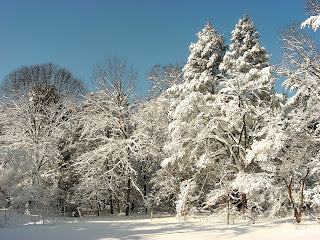
Snow on Terwood Run

A professional photographer friend of mine, Mark Schmerling, shared these images of Terwood Run, a small tributary to "my" creek, taken just after the latest snow fell on January 27, 2011.  Mark specializes in taking pictures of rocky streams from a water-level perspective.
_____
I developed Reynaud's syndrome in my right index finger this morning.  The last time this happened, Kali (and I) freaked out and got me to the doctor's office as quickly as we could.  It is disconcerting - my finger turned purple and got cold and stiff -  I was sure gangrene was imminent!  The doctor calmly diagnosed the problem and told me to keep my finger warm by immersing it in warm water.  Sure enough, the symptoms disappeared.  I'm repeating the treatment today by wrapping my fingers around generous mugs of hot cocoa.

Friday, January 28, 2011

Enough Already!

January 26-27 brought our fifth winter storm so far this season, and this one delivered the most snow (15 inches in two bouts, one with four inches during the day on January 26, and then a "snow burst" that dropped 11 inches between 8 p.m. on Wednesday and 1 a.m. on Thursday that included snowthunder and lightning).  Snow from the previous storms hadn't even melted!

There's a Junco just below the seed tray
It was beautiful, but I've had enough.  We're well over our annual average snowfall already, and we're still in January.  My back and arms ache today from all the shoveling I did yesterday - good thing it was aerobic exercise, since I certainly can't go for a walk.
Sunrise

Monday, January 24, 2011

Movement Weekend

Great dance weekend.  Saturday night, a new contemporary dance company, Keigwin + Company, was in town performing their Elements cycle of dances related to water, fire, earth and wind.  Larry Keigwin choreographed 15 pieces with new moves, imaginative costuming, interesting music, and lots of humor and O'Henry-esque surprises.  The dancers gave it their all, and the audience (and I) clearly appreciated their efforts.  You know a company's done a great job if you leave the theater energized and motivated to move more and get into better shape yourself.


Brian Sanders / "Urban Scuba"
Then, Sunday afternoon, it was back downtown for a matinee of contemporary dance and physical theater created by Philadelphian Brian Sanders in his 18-3/4 Anniversary Season of JUNK.  Sander's company uses found objects -  ladders, bicycles, and trash cans -  as well as carefully fabricated objects incorporated into dances and movement pieces.  JUNK was a retrospective of 18 pieces gleaned from Sanders' 18-3/4 years of producing dance, and nearly all were spectacular.  The dancers were in perfect physical condition and incredibly strong: I'm heading to the gym!
"Urban Scuba"
 

Friday, January 21, 2011

New Mexico: Solitude Canyon, Bosque del Apache

Approach to Solitude Canyon
The "action" at Bosque del Apache National Wildlife Refuge is focused on the heavily managed and manipulated marshes and wetlands on the Rio Grande floodplain.  But large sections of the refuge are Chihuahuan desert uplands well away from the river bottoms.  Three portions of the refuge have been protected in wilderness areas, and we chose to explore the periphery of one of those areas before we headed back to the airport.

A mile south of the refuge's main entrance there's a turnout and parking area off NM Rte. 1 that provides access to the Solitude Canyon trailhead.  The developed trail is a 2.2-mile lasso-shaped introduction to the desert.
View from within Solitude Canyon
The first half-mile of the trail gradually ascends the very sandy alluvial outwash from Solitude Canyon.  But, once the trail enters the canyon proper, it crosses over into the Indian Well Wilderness Area and the entire landscape changes.  Instead of traversing open ground, the trail follows the course of the Solitude Canyon arroyo, bringing walkers into close contact with the poorly cemented sandstones and unconsolidated gravels that make up the canyon walls.  As Kali said, "It finally got interesting."  Once the trail climbs out of the canyon, it loops northward and then delivers walkers back to the mouth of the ravine.

It was cold and windy on our walk.  As a result, we saw but one unidentifiable sparrow flit across our path during the entire walk.  Within the canyon, though, there were many eroded cavities and niches high up on the sandstone walls where Common Ravens had raised broods.  Some of the holes looked like they had been used for many, many breeding seasons.
The sandstone and gravel walls of Solitude Canyon

New Mexico: Sandhill Cranes and Snow Geese at Bosque del Apache

In 2003, I visited Austin, Texas, for a conference. On my first night in town, I walked downtown just before dusk and gathered with hundreds of other people at a park below the Congress Street Bridge over the Colorado River and waited.  As the light waned and darkness increased, first a few, and then a thousands of Mexican Free-tailed Bats emerged from their diurnal roosts under the bridge to head out into the surrounding farms and ranches to feed.  There were so many bats that they looked like dense smoke billowing skyward.  I have to admit that I was overcome with emotion at this natural spectacle - tears welled in my eyes and my throat choked up.  I'm glad that it was dark so that no one could see macho man reduced to blubbering.

Though it didn't get that far in New Mexico, seeing countless thousands of Snow Geese suddenly explode from the surface of a marsh, wheel around in the air for a minute or so, and then settle back onto the pond nearly invoked the same reaction.

Our third natural history stop in New Mexico was Bosque del Apache National Wildlife Refuge just south of Socorro.  One of the main reasons we planned to visit southern New Mexico in January was to stop at Bosque del Apache, where thousands of Sandhill Cranes (Grus canadensis) and Snow Geese (Chen caerulescens) overwinter.
We were not disappointed.  We first spotted cranes in three "outlier" ponds as we drove along the access road (NM Rte. 1)to the refuge, and then saw thousands more foraging in the corn fields that are planted for the cranes and the Snow Geese within the the refuge proper.
We spent a full, glorious sunny and warm day at the refuge - our warmest in New Mexico.  We tallied about 25 species of birds (plus two handsome coyotes and three mule deer) on our 12-mile drive around the marshes and farm fields in the refuge - far fewer than we had seen on our March visit a few years ago, but a respectable number for the winter according to one of the refuge naturalists.  None of the birds we spotted was new for us, but we really came for the astounding numbers of cranes gathered there.
Bald Eagle on a snag
One of three Bald Eagles Eagles we observed.  Image captured with the optical zoom of my point-and-shoot Nikon.
As sundown approached, we positioned ourselves along NM 1 once again for one of the refuge's daily winter highlights: the "fly in."  As the sun goes down, cranes and geese fly back to the safety of the refuge's marshes and ponds for the evening from their day's foraging in the surrounding landscape. Hundreds and hundreds of birds approach in squadrons and land in the wetlands.  (The reverse half of the spectacle, the "fly out" at dawn, has not been impressive this year according to refuge volunteers because the traditional gathering wetland has been frozen over and, instead of congregating in one gigantic flock that takes off at sunrise a la Austin's bats, the cranes and geese have divided themselves into smaller groups at ponds scattered throughout the refuge where the water remains open.
We returned to the refuge two days later before we headed back to the airport for a final look at the cranes and to try to spot an Aplomado Falcon that had been seen frequenting a grove of cottonwoods, but the day was very cold and windy, the ponds where we had seen the cranes two days earlier were frozen, and there was no sign of the falcon. 
A Great Blue Heron for Grizz

Tuesday, January 18, 2011

New Mexico: Hike to Dripping Springs, Organ Mountains

Approach to Dripping Springs Canyon
On the afternoon of our last day in Las Cruces, we took the one-mile walk to Dripping Springs on the western flank of the lava-derived (southern) portion of the Organ Mountains (see previous post for more about the geology of the region).

The Chihuahuan desert is very dry, and these dependable springs have been known for centuries.  Just down slope of the actual springs, archeologists excavated the floor of a rock shelter (La Cueva, The Cave) that contained evidence that the canyon containing the springs has been occupied by people for millennia.

Between the end of the 19th century and the 1930's, the Dripping Springs canyon was the site of mountain resorts and a sanatorium.  When the first, wood-framed resort failed, it was turned into a tuberculosis sanatorium.  Eventually, that site was abandoned, but a new, larger resort with stone buildings was built further up the canyon.  The remains of the wood-framed and stone buildings are scattered throughout, as are two silted-up reservoirs that were built to contain and store the water from the springs.

A coup used to house chickens for the resort

Remains of the sanatorium
The stone hotel at the mountain camp
When we visited, the spring flow was unimpressive - either the springs are very modest affairs, or they flow more generously in other times of the year.  In fact, it was difficult to see the water dripping out of the canyon above.  Nevertheless, it obviously provided enough water to operate the resorts successfully.
The Dripping Springs (bottom center)
The canyon and the springs were saved by The Nature Conservancy (TNC), which bought the property and then sold it to the Bureau of Land Management for a protected natural area.  Because of the presence of the water, the canyon supports rare and endangered plants, prompting TNC's interest.  The hike up to the springs from the visitor center was a relatively easy one-mile uphill trek on a gravel road that had previously been used to service the resorts.
View westward toward Las Cruces and the Rio Grande valley

Monday, January 17, 2011

New Mexico: Hike to Baylor Pass, Organ Mountains


Our fifth trip to New Mexico.  If everything works out (a big "if," of course), we'll almost certainly retire there.  The question is: where?  This trip to the south-central part of the fourth largest state in the union confirmed our love for wide open spaces and the Chihuahuan desert.  We can think of far worse places to land than Las Cruces, for example, the second-largest metropolis in the state.

Our first hike during this New Mexican trip took us to the Baylor Pass Trail in the Organ Mountains about 20 miles east of Las Cruces.  As a mountain range, the Organs are relatively small.  They don't even show up on my Rand McNally road atlas of New Mexico.  Nevertheless, they are dramatic because they are so craggy.  Though I beg to differ, I read several comparisons to Wyoming's Grand Tetons in Las Cruces Chamber of Commerce promotional material.
Chihuahuan desert vegetation along the trail
The mountain range has two origins.  The northern half - the dramatic, craggy half - is the eroded remnant of a batholith.  Magma pooled under the earth's surface but never broke through, cooling and solidifying underground.  The southern end of the mountains is the remnant of magma that did breach the earth's surface in a typical volcanic eruption.  The suture between the two is plain and stark:  the northern batholith is light pink-gray granite, while the southern is dark brown lava.
View southward along the eastern flank of the lava-derived portion of the Organ Mountains
The Organs are also one of the numerous "sky islands" that dot the southwest all along the Mexican border.  Unlike oceanic islands surrounded by water, the sky island mountain ranges are separated from one another by desert "seas," making them hotbeds for speciation and endemism.
Snow along the trail from a storm one week earlier.  The divided peaks are called the Rabbit Ears.
We chose to walk the Baylor Pass National Recreation Trail.  The 6-mile trail traverses the mountains, crossing at Baylor Pass.  The approach from the east reaches the pass in 2 miles, while the approach from the west requires a 4-mile hike to reach the pass.  We selected the shorter hike, climbing about 900 feet from the trailhead to the pass and then returning on the same route.  With leisurely breaks for birdwatching, photography, and lunch, the trek took us about four hours.   Temperatures were in low 50s - perfect for hiking, especially when the sun is out.  I even got a bit of a sunburn!
View eastward from Baylor Pass over the Tularosa Basin

Along the trail

Friday, January 14, 2011

Ice Rings

 Kali and I just returned from a week in southern New Mexico, so I'll post about our exploration of the Chihuahuan desert natural world over the next few days.

In the meantime, some images of ice rings that formed in a pool alongside my creek.  These images were taken by a colleague from New York City when she and I went for a walk in my natural area on December 14--before we were buried by two snowstorms.